Monitoring Change
NASA's Cryosphere Science Program
Derived from the Greek word 'krios' meaning 'cold,' the cryosphere encompasses the regions on Earth that experience sub-zero temperatures for at least part of the year. Its largest regions by far are the ice sheets in Greenland and Antarctica.
Within this program, are a number of operations that use long-term observations available from satellites and aircraft, to better understand key relationships within the Earth system

At present, the Cryosphere Science Program's highest priorities are the understanding of these two polar features:
1. Terrestrial ice sheets of Greenland and Antarctica with an emphasis on acquiring data to characterize them and develop predictive models of their behavior and contributions to sea level change.
2. Arctic sea ice, with an emphasis on determining its status and the controls on its extent and thickness.


ICESat
Ice, Cloud, and Land Elevation Satellite was the benchmark Earth Observing System mission for measuring ice sheet mass balance, cloud and aerosol heights, as well as land topography and vegetation characteristics.
From 2003 to 2009, the ICESat mission provided multi-year elevation data needed to determine ice sheet mass. ICESat 2 was launched in 2016 and is still operating today.

Operation IceBridge
Operation IceBridge is the largest airborne survey of Earth's polar ice ever flown.
IceBridge Mission Statement:
NASA’s Operation IceBridge images Earth's polar ice in unprecedented detail to better understand processes that connect the polar regions with the global climate system. IceBridge utilizes a highly specialized fleet of research aircraft and the most sophisticated suite of innovative science instruments ever assembled to characterize annual changes in thickness of sea ice, glaciers, and ice sheets. In addition, IceBridge collects critical data used to predict the response of Earth’s polar ice to climate change and resulting sea-level rise. IceBridge also helps bridge the gap in polar observations between NASA's ICESat satellite missions

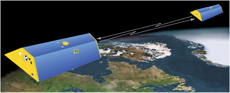
GRACE
The twin Gravity and Climate Experiment (GRACE) spacecraft observe and measure the gravitational field of Earth. Launched in March 2002, the findings from this mission lend insight on the shape and composition of the planet and the distributions of water and ice.
Among its many innovations, GRACE has monitored the loss of ice mass from Earth's ice sheets and improved understanding of the processes responsible for sea level rise and ocean circulation.

MODIS
The Moderate Resolution Imaging Spectroradiometer is an important instrument aboard the Terra and Aqua satellites. MODIS data plays a critical role in the development of Earth system models that assist with environmental change predictions.
In August 2017, MODIS captured remarkable images of a massive wildfire burning on Greenland's west coast. Click the image to the right to watch a short video produced by NASA about this phenomenon.